The Victorians and Indians built 50,000 miles of railways in India. (Stanley Wolpert, in his splendid India)
Fifty thousand miles is about 12 times New York to San Francisco. India, if you turn her on her side, just fits inside the lower forty-eight. And the steel, locomotives and rolling stock were manufactured in the UK (much of it in Birmingham) and shipped out.
Astonishing?
This page is intended to celebrate Mr. Trott's map as a worthy participant in such a grand achievement.
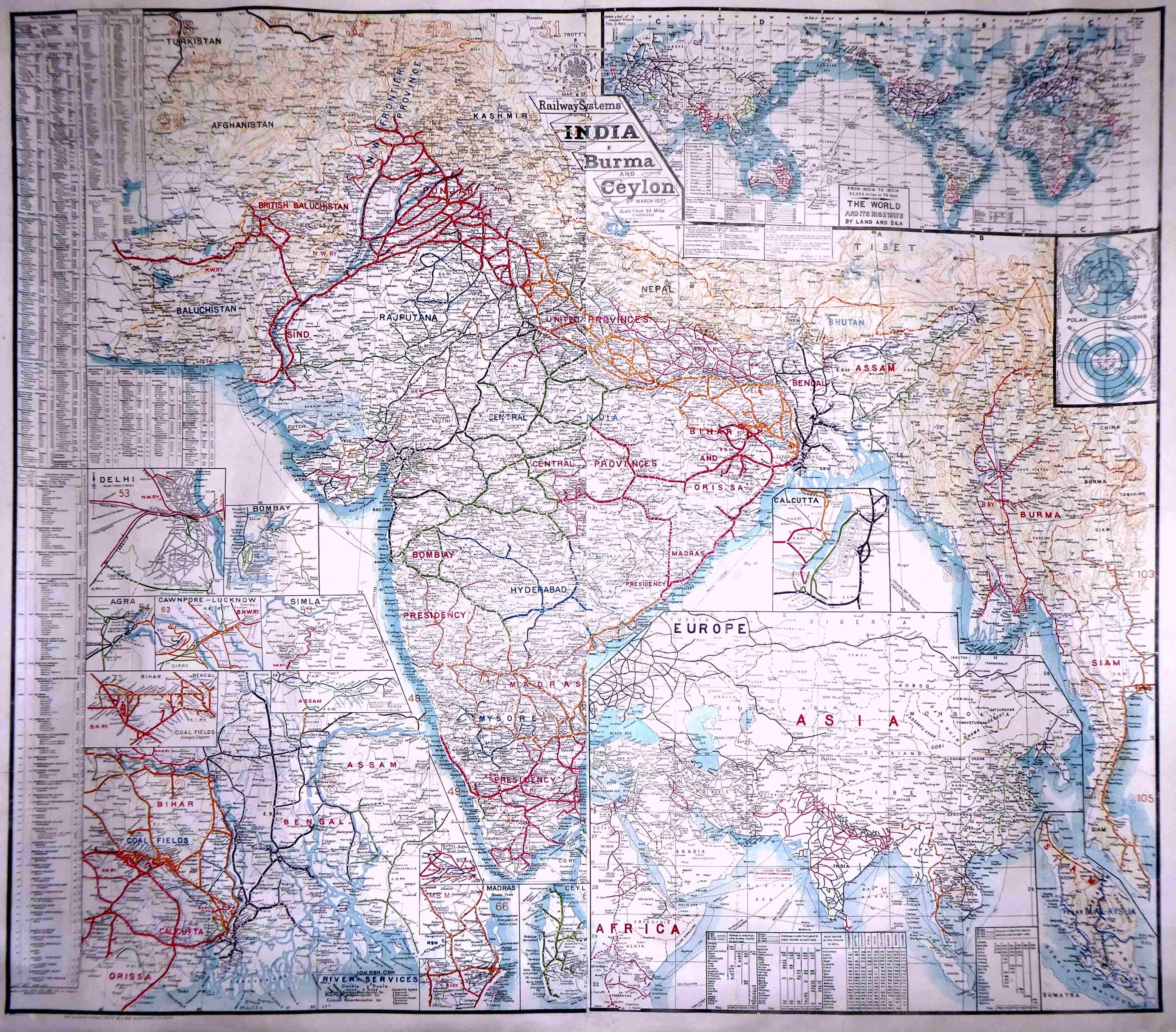
Here is just a tiny bit of the map, so you can see the level of detail, and the beautiful design...
I fear that this web page is very sad in comparison to all of that. I do what I can, be it ever so feeble.
The image immediately above is of a strip about half the width of the whole map. (It is from the lower left of the whole, which you can see a little ways further down this webpage.)
The whole map is about a meter by a meter. The lower strip above is about an eighth of the information on the map.
If you think "Yawn. That's not so special," then please send me a list of just the names in a quarter of what's in the image above. You don't have to show where they are. You don't have to send the details from the table that is at the left. You don't have to show the railways. Just send a list of the names. Now.. you may not CARE about the information, but please don't try to tell me that there's not much here.
It takes a lot of wall space... but it is glorious!
By the way, a moment ago I said "I do what I can do." If this map had been produced by a team of 200 working in the offices that ran (for better or worse, let's leave that for another day?) a very large part of the world for a time, the map would be easier to understand.
However, it is my understanding that it was produced, almost as a hobby, by one of the Indian station masters. Obviously, he drew on others for information, etc. But as far as I know, he had no "big team", no "official" organization behind this, his tribute to what it seems he was very proud to be a part of. (Bookseller Mr Gerald Baker, of Bristol England said in his description of a similar map "J H Trott was the Station Master in Bilaspur". A friend pointed me to something in the journal of the RGS indicating that "JH Trott" was probably J Harrington Trott. (Details in HTML comments).
At some point, I hope to extend this page, do more images of detail, and also write up a "tour" of the many bonus items squeezed into any bit of the page that looked in danger of going unused.
If this map had only delivered, in any format, the material in text, it would impress me greatly.
Those bits of text report some obvious things... and some that are less obvious.
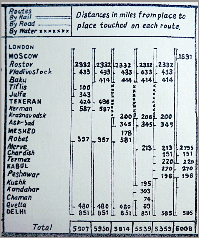
What do you make of this?
You're brighter than I am if you saw instantly what Mr. Trott's table tells us.
After a bit of head-scratching, I concluded that he compares several journeys from London to Delhi. The shortest?...
Sooner you than me- today. Let alone in 1927.
That's 40 cm2 of the "map" briefly discussed. Just the reading of it, not the creation of it. Only about 9060 cm2 to go...
Created without a computer, without GPS, without...
(^_^)
Here I am giving you preliminary versions of things I hope to work up more beautifully eventually. Apologies for the crudeness at this stage, but I hope you will feel that's not to great a distraction, and that you will enjoy the elements of the map which I am celebrating.
REMEMBER- although I think you can be forgiven if you forget!... all of the following is part of a map ostensibly depicting the Indian railways, c. 1927. It seems Mr Trott could abide "waste" as litle as I can, and felt that every square centimeter needed something!
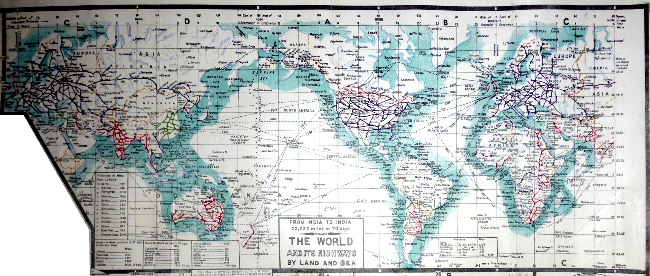
This is placed at the upper right of the whole. It is about 50cm wide. Besides showing ther railways elsewhere, it speaks of a journey "from India to India by Land and Sea", and says that it would entail 22,222 miles (... not, say, 22,200!), and take 70 days. Eat your heart out, Phileas Fogg! Though I suppose shaving 10 days from the journey isn't much to ask of an extra 55 years of Victorian "progress".
This, remember, is "just a little space filler"... not "the map" you got when you bought Mr Trott's map of the Indian railways.
I'd say the map below, on its own, would deserve a place on my wall. Would be perfectly legitimate as "all" you got for your money"
What you see below is just a small part of the big map of the Indian Railways. Beside it, I have inset a map of the railways in Wales and part of England showing their railways about 30 years before the era shown on the Indian map.
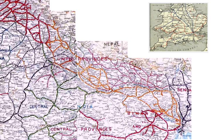
It is hard to believe that the scaling right. It "must" be wrong... But several checks I have made suggest that it is not. (And since writing what I said at the start of this paragraph, I've done the new check set out in the next paragraph....
Delhi is on the portion shown of the Indian map. The Punjab is at the upper left, and Kolkata at the right. (That's about 1,000 miles, vs the full width of the England map at about 300 miles.)
This graphic blows my mind. I could not believe that the scaling was right, at first.
I am sure that the map of the Indian Railways is Mr. Trott's of 1927. And the inset map of the English railways is how they stood in 1898. (Details of the source of that map may be found in the comments embedded in this page's HTML. It is, in a nutshell, from "Pitman's Commercial Geography of the World", publ 1898).
Remember: In the early days, while the first 50,000 miles of the Indian railways were being laid, the rails were shipped from Britain. And the engines. And the rolling stock. (As finished goods). The Victorians... with Indian labor... Got Things Done!
(Many people, again, partly due to "projections", misunderstand the sizes of different countries. I also offer a page with a examples of the true size of a few countries and regions.)
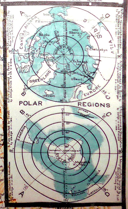
I think that by 1927 the Royal Geographical Society knew a bit more about Antarctica than shown below... but how many other people did? (No one had crossed it yet. Aircraft didn't reach it until 1928.)
Anyway, I say "good on 'ya" Mr. Trott, if only for using the unusual projections!
I've barely scratched the surface of all that this amazing map offers... but I hope you've enjoyed the little bit I've done so far, even though it isn't done very well so far.
Your thoughts would be very welcome. (Contact details below.)
The library at the University of Illinois has a fabulous page where you can explore an earlier version of the Trott Indian Railways map.
If anyone can send me a link to information about J.H. Trott, I would be very grateful. (Eddress below).
Please get in touch if you discover flaws in this page. Please mention the page's URL. (wywtk.com/boma/ind-rlwys/ind-rlwys1.htm).
If you found this of interest, please mention in forums, give it a Facebook "like", Google "Plus", or whatever. If you want more of this stuff, help!? There's not much point in me writing these things, if no one feels they are of any use.
|
Unlike the clever Google search engine, this one merely looks for the words you type, so....
* Spell them properly.
* Don't bother with "How do I get rich?" That will merely return pages with "how", "do", "I"....
Please also note that I have three other sites, and that this search will not include them. They have their own search buttons.
![]() Page has been tested for compliance with INDUSTRY (not MS-only) standards, using the free, publicly accessible validator at validator.w3.org. It passes in some important ways, but still needs work to fully meet HTML 5 expectations..
Page has been tested for compliance with INDUSTRY (not MS-only) standards, using the free, publicly accessible validator at validator.w3.org. It passes in some important ways, but still needs work to fully meet HTML 5 expectations..
AND passes...

....... P a g e . . . E n d s .....