On a typical Autumn day in 2018, thirty thousand passengers arrive or depart from Bristol[1]. Untold freight travels over the same rails.
In 1818, there was no inter-city passenger-carrying railway anywhere. (The first was between Liverpool and Manchester, started 1830. Isambard Kingdom Brunel's Great Western Railway route from London to Bristol was completed in 1841 [2]... but read on!...)
This web page is about a map. The map is about the beginnings of the GWR. Besides this page, I also have a page about a similar but later map. That one is part of a 1834 prospectus for the Great Western Railway. (The 1834 map came my way because I make sure to stop in at Tim Bryars' splendid emporium in Cecil Court from time to time. Always good things to be found there, in maps and in books!)
(Some of the images have had minor repairs with photo manipulation software.)
There are images of details, below.
The GWR was built no more quickly than Rome.
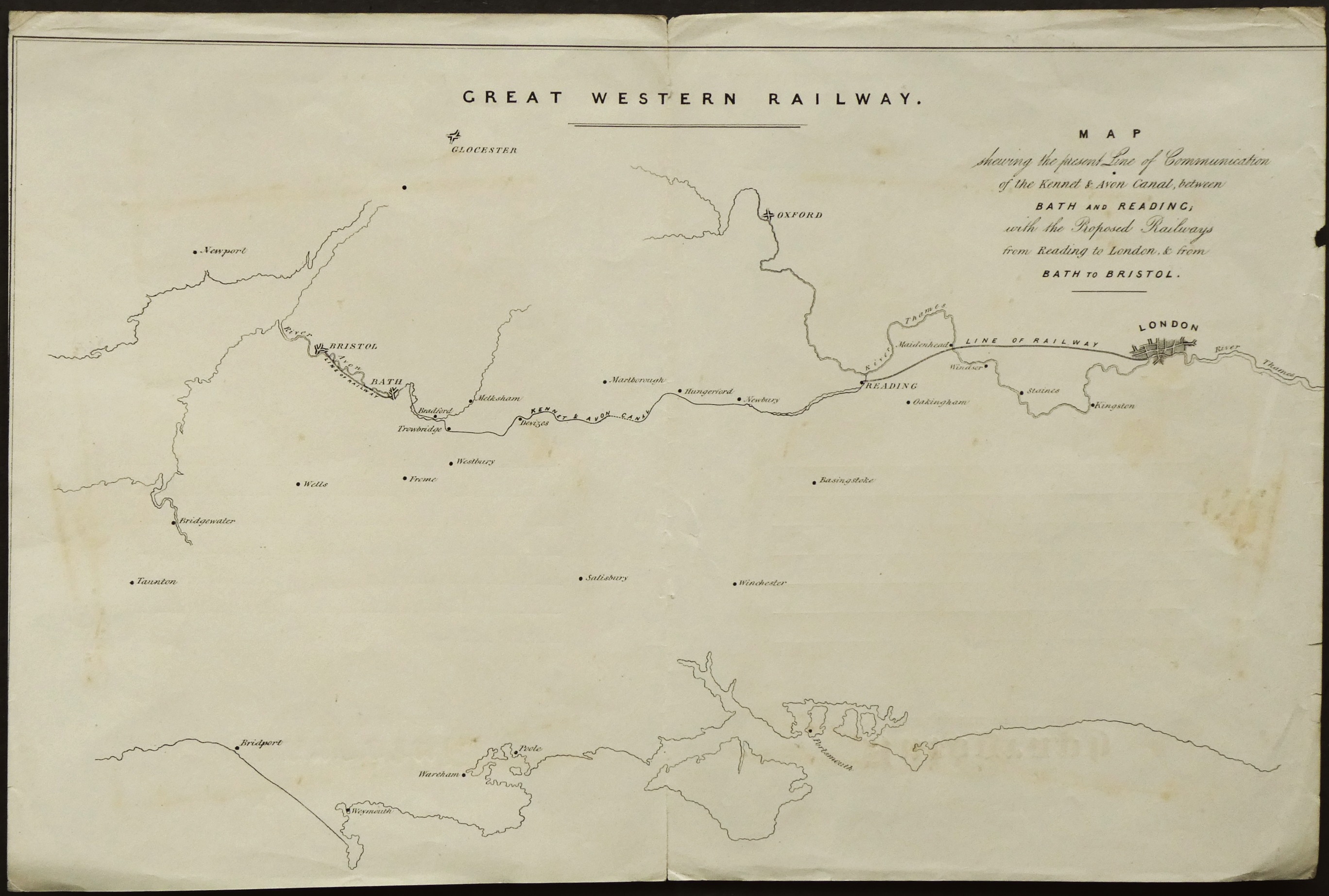
The map speaks of a possible first stage...
Hardly the non-stop journey passengers and freight can enjoy today! But Bath and Reading were not chosen out of a hat...
Travelers could use rivers and the Kennet and Avon canal, completed 1810, to traverse the gap between Bath and Reading... also shown on the map.
Before the canals, and then the railways, the least bad option for passengers was the mail coaches. For a splendid insight into that era, see Edward Corbett's 1890 An Old Coachman's Chatter, with Some Practical Remarks on Driving. (The link will take you to a page in Gutenberg.org where you can read it online, or fetch a ebook. (For free, no registering, etc.)
But railways not only made passenger travel easier. They, and the canals before them, were a critical element in the Industrial Revolution. What's the use of a factories to make vast quantities of good cloth, cheaply, if you don't have a way to receive vast quantities of wool, cotton and dispatch vast quantities of finished goods to your customers? The roads were particularly unsuited to the needs of the The Potteries.
(The map is 30 x 44 cm. Printed on the "inside" of an opened out "wrapper" for correspondence! A printer's proof?)
I don't have a date for the map. I was told by the seller that it is the first document bearing "Great Western Railway". It is clearly an early map.
The company officially began in 1833. Isambard Kingdom Brunel, then aged 27, was appointed it's engineer in 1833 is how the Wikipedia entry is written. But where did the GWR come from? I believe it was the product of young Brunel's dreams. Was this map produced after 1833... or was it something he worked up to help him persuade his investors to found the company?
Remember: As a map of "the GWR's Bristol to London line", this map has a huge gap.
In due course... before 1841... Brunel added a loop to the north between Bath and Reading.
How close to the dreams of an inspired young man is this map?
Keep in mind that you can't just plonk a railway where it suits you. Inconvenient things like substantial hills, river, sub-soil geology, existing infrastructure, and costs have to be considered.
Where, in the early 1800's, do you get access to something as simple as a map with the necessary detail to choose a railway route?
I hope your appreciation of this superficially insignificant little scrap of history is growing?
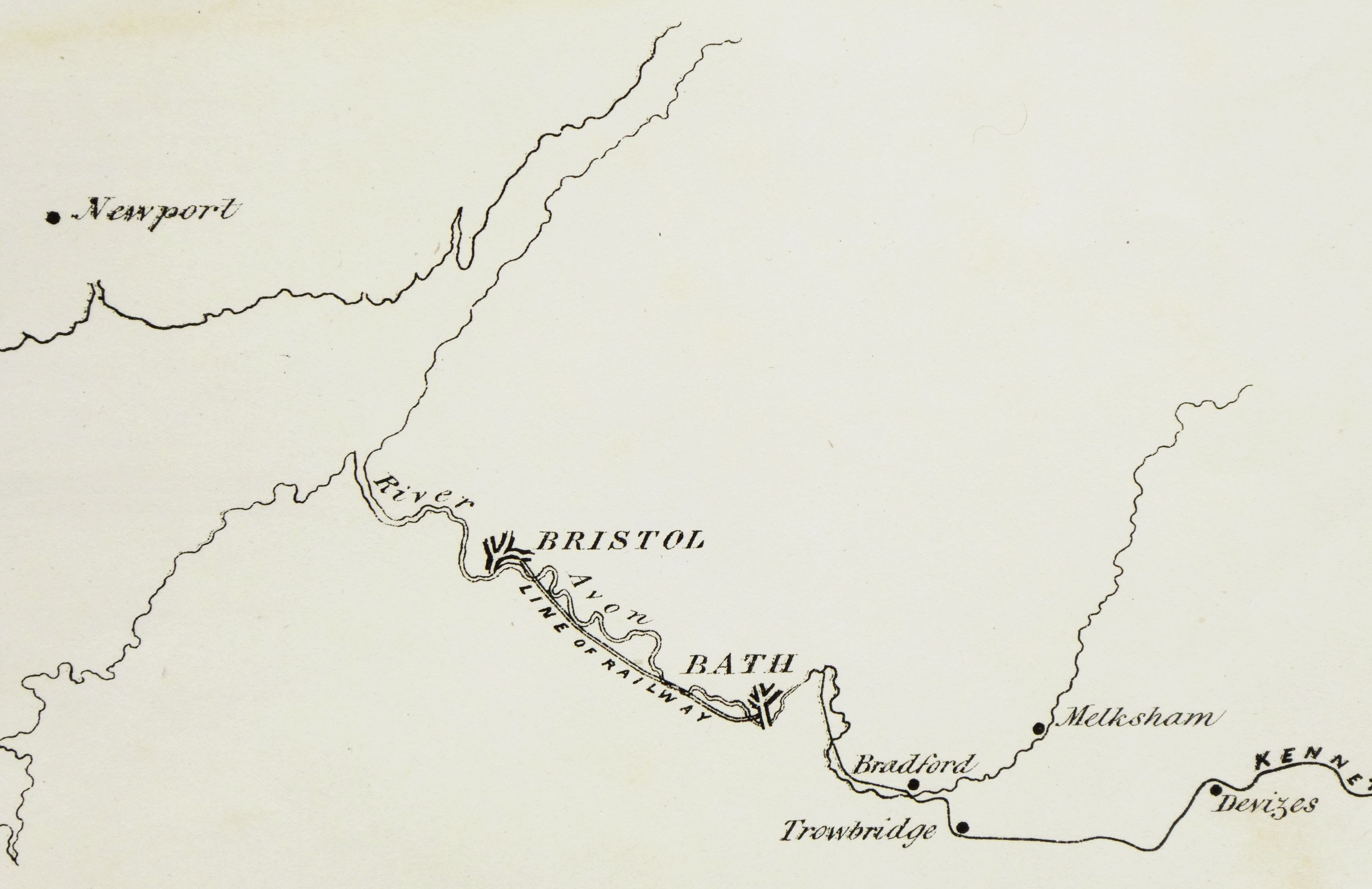
Here we have, in more detail the western end of the beginnings of the GWR...
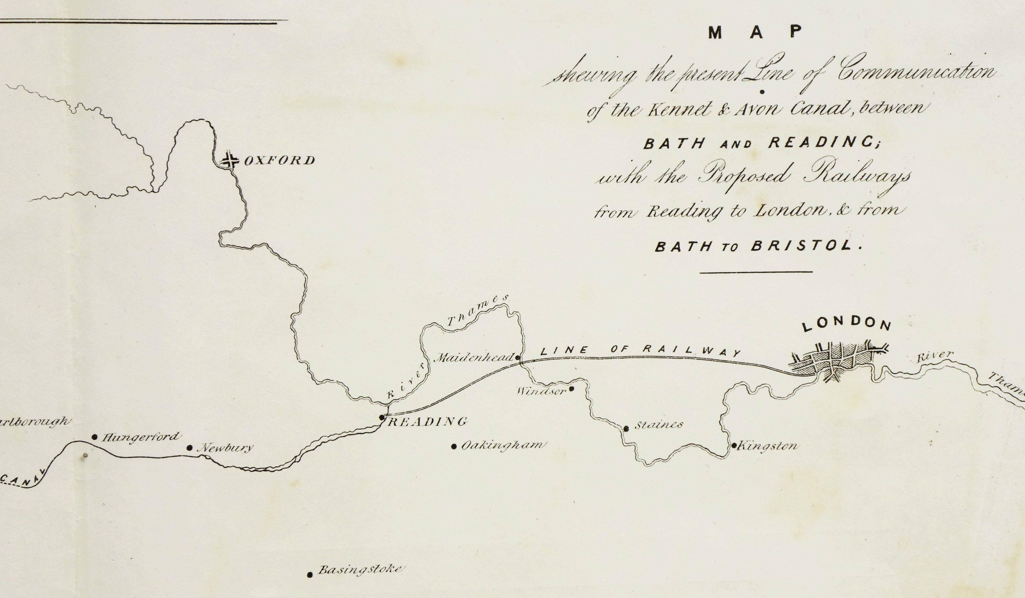
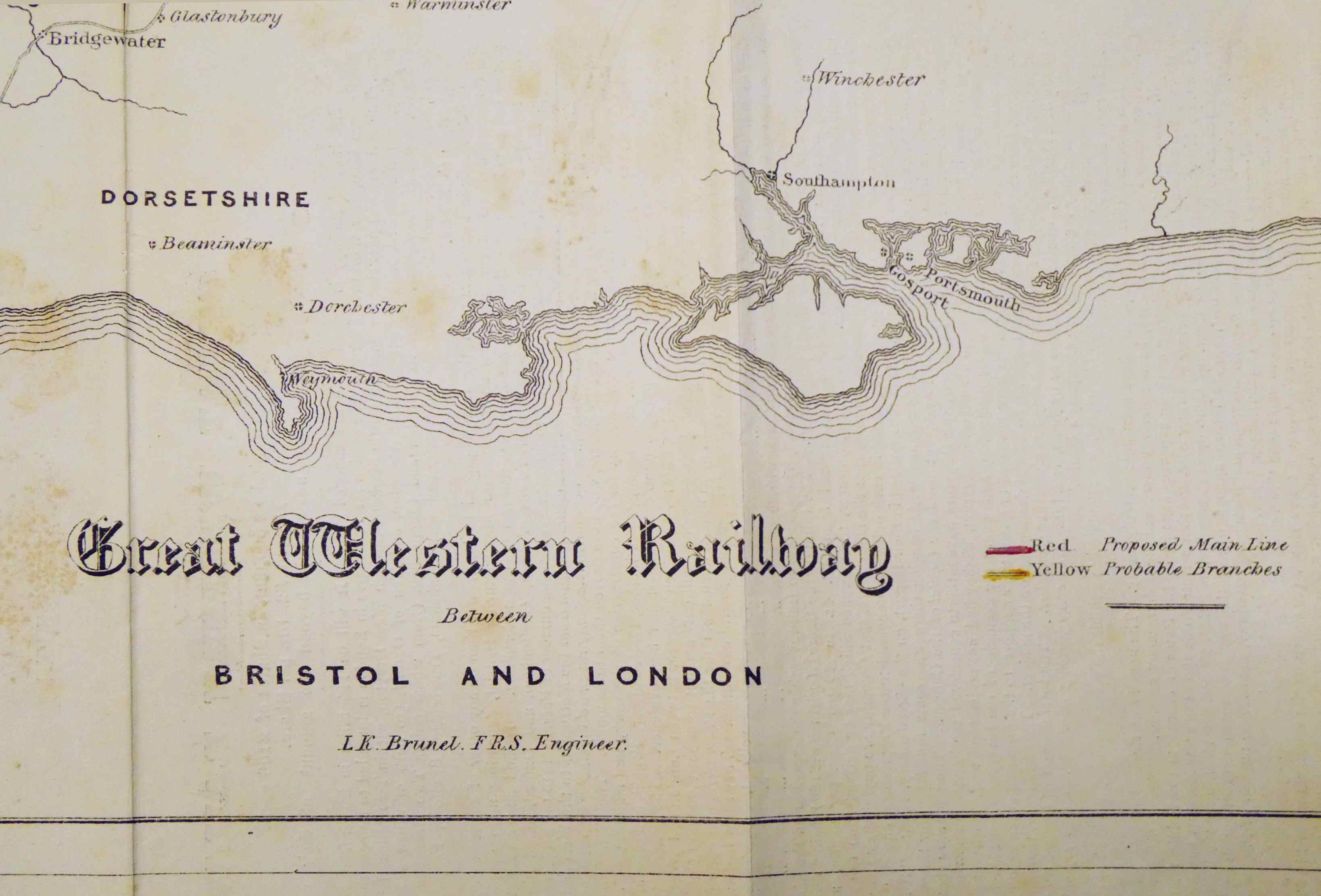
Here we have, in more detail the eastern end of the beginnings of the GWR...
I believe I was told by the seller that this map was of an early, abandoned (or defeated!) proposal.
Be that as it may... it seems certain to me that it was at least a step along the way of Brunel's extraordinary achievement.
This map this page is about comes from before 1834. All the images above are of the earlier map.
I have another page about a similar map from 1834, which shows how the goals of the project have been refined. The 1834 map is on the back of a prospectus inviting investment in the company, which had been set up in 1833.
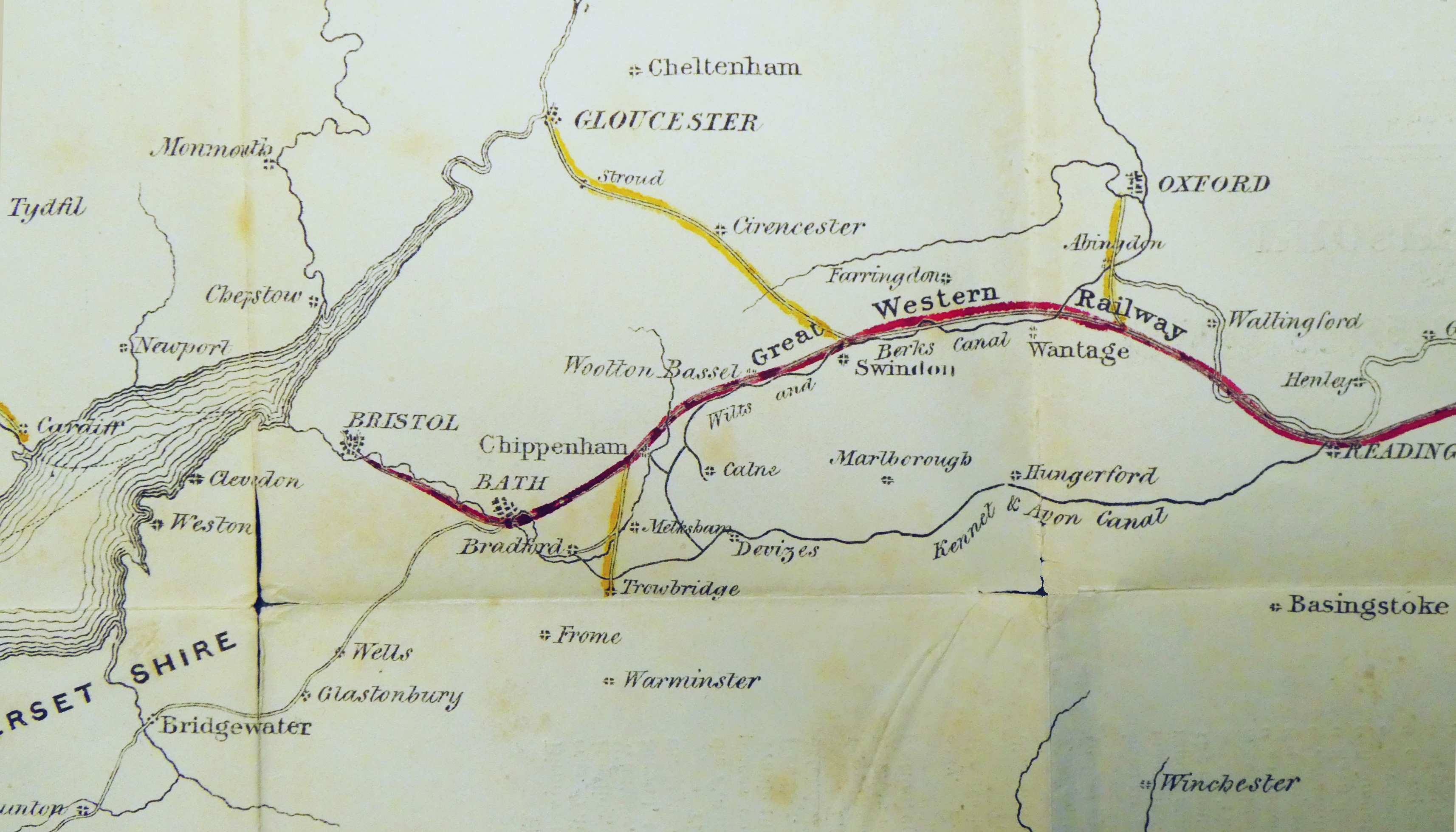
The image below comes from the 1834 map. I hope it amuses or even interests you to compare the 1834 plans with the earlier ideas, shown in a comparable image above.
The red line is the proposed main line. The yellow lines show branch lines the company directors thought were probable.
Speaking of comparisons....
Scroll up, look at the text, legends, etc, on the early map.
Below is the equivalent on the 1834 map. The project is gaining momentum, I think!
===
===
References...
[1]
"Rail passenger numbers and crowding statistics: 2018 report", Accessed 18 Sep 23 from
https://www.gov.uk/government/statistics/rail-passenger-numbers-and-crowding-on-weekdays-in-major-cities-in-england-and-wales-2018
... which gives you access to...
https://assets.publishing.service.gov.uk/government/uploads/system/uploads/attachment_data/file/820770/Rail_Passenger_Numbers_and_Crowding_2018.pdf
---------
[2] I am indebted to Wikipedia's GWR article, accessed 18 Sep 23, for the accuracy of many of the basic facts in this.
Please get in touch if you discover flaws in this page. Please mention the page's URL. (wywtk.com/boma/gwr/gwr1main.htm).
If you found this of interest, please mention in forums, give it a Facebook "like", Google "Plus", or whatever. If you want more of this stuff, help!? There's not much point in me writing these things, if no one feels they are of any use.
|
Unlike the clever Google search engine, this one merely looks for the words you type, so....
* Spell them properly.
* Don't bother with "How do I get rich?" That will merely return pages with "how", "do", "I"....
Please also note that I have three other sites, and that this search will not include them. They have their own search buttons.
http://www.arunet.co.uk/tkboyd/index2.htm My site at Arunet.
![]() Page has been tested for compliance with INDUSTRY (not MS-only) standards, using the free, publicly accessible validator at validator.w3.org. It passes in some important ways, but still needs work to fully meet HTML 5 expectations..
Page has been tested for compliance with INDUSTRY (not MS-only) standards, using the free, publicly accessible validator at validator.w3.org. It passes in some important ways, but still needs work to fully meet HTML 5 expectations..
AND passes...

....... P a g e . . . E n d s .....