
This is a detail page, among several which show you how you could make a map. Yourself. No Google. No electronics.
It reports on a second measurement (May 23) of something already measured once- (June 22)!
This link will take you to the "parent page", the "root" page for this set of pages.
Details another time, but I did this 55 years after I first started thinking about it. When I say "this", I mean "drew the following map", based on data collected by me, from a specific baseline, to a specific distant point.
The point of the map was to determine the distance between the baseline and the distant point... Although, as you know if you've studied the other pages in this set, it could be the start of a map showing more than just the baseline, and the location of one distinctive house a little more than a mile from it.
The baseline was marked out. North end called "A", south end "B". "Flags" set up to mark the ends.
The theodolite was set up at the north end of the basesline, as close to over the north end of the baseline as possible.
It was pointed at the chosen feature on the building across the valley (About a mile away. Apologies for the mix of units! In fact I had to repeat most of the exercise due to a mistake. In doing that, I at least corrected a mistake made early in the day. My first measurement of the baseline had been done in feet and inches... not the nicest units to work in!)
The place where you read the bearing was photographed. That was photo "20230514_093631"....
![[[img 20230514_093631.jpg should appear here]]](gra/20230514_093631.jpg)
It shows a reading of 151°, 49' (151 degrees, 49 minutes.)
(I will try to explain how to "read" the scale later.)
The theodolite was then pointed at the flag at "B", the south end of the baseline.
And the place where you read the bearing was photographed. That photo is on the photos page, ID="20230514_093713". It shows a reading of 38°, 45'. (I'll give you link to photos page later.)
Subtract them and the answer gives you a first result for the size of angle CAB- 113° 04'.
Digression...
When you have a first determination for the second angle, from photos 20230514_095206 and 20230514_095309, you can sketch...
![[[img may23_first_sketch.png should appear here]]](gra/may23_first_sketch.png)
Digression ends. Back to work!...
The "card" in the theodolite was then moved a bit. And the above process repeated. And that was subsequently done once again. Why? To create THREE measurements of angle CAB. If they agree, then some errors which might have been made have not been made. If two are pretty close to one another, and the other isn't, maybe they are right, and some mistake was made doing the third one?
So... thus far there should be 6 photos, from which 3 measurements of CAB can be determined.
The theodolite was then moved to position B, and the whole process repeated. It was pointed at C. Photo taken of place bearing is read from. Pointed at A. Photo taken. First measurement of CBA calculated.
The two steps just described repeated twice more. Two more measurements of CBA calculated.
That was the plan. I should have had 12 photos. But it turns out I only have 11 photos. I fluffed one. And I don't know which one. (It seems I forgot to take the last of the 12.)
I'm pretty sure I took the first 4 photos. Whew. The two angles they report are about right for the real world situation being mapped. Whew. I'm afraid working out which other photo was fluffed is left as an exercise for the student. I don't know myself at the time I am writing this up for you! If you think about it, you will see that it deprives us of one reading of either CAB or of CBA. :-(
The first photo is identified by "20230514_093631". It stands for year: 2023, month: 05, day: 14.... Hour: 09, minutes past hour: 36, seconds: 31. The ID's were used for the .jpgs on the camera, and have not been edited by me since they were created. So we can at least know the sequence the photos were taken in. And I'm pretty sure I stuck faithfully to the sequence of steps set out above.
If you want to take on the challenge, I suggest you make a list, and write down the last four digits of the photo IDs, and next to each place the reading you get from the following images. They have been presented in the sequence in which they were taken.
Once you have those numbers, try subtracting adjacent numbers. With a little thought, you should be able to decide which photo is missing. My first quick guess? It was the LAST photo I needed to take that was the one that I forgot to take. So you only have the numbers to provide two, instead of three, determinations of angle CBA. Sorry!
When you know which photo is missing, you can produce a table of the 5 angle measurements that can be determined from the photos. A copy of your result would be very welcome for this page!
PHOTOS: This link will take you to a page with 11 images taken while measuring the width of the valley.
Last time I used a plane table to measure the necessary angles. This time I was using an antique theodolite I bought in a yard sale some years ago.
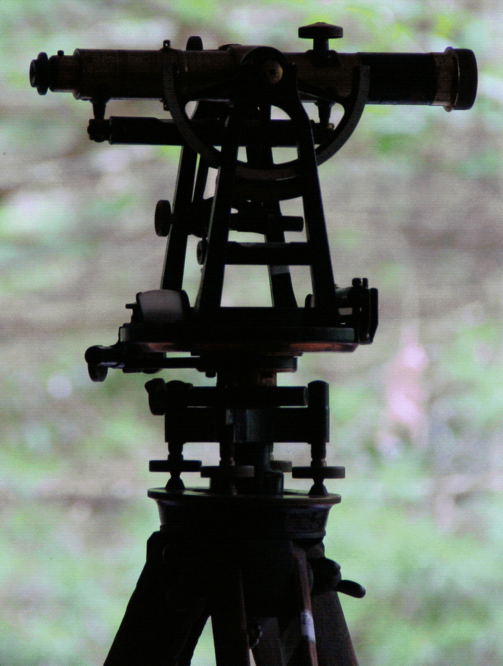
It is a wondrous thing of great beauty... but before there were alternatives, it was a very expensive instrument. Now it is "junk". Sigh.
Fear not! As explained in other pages, you can make your own! Or use other alternatives.
---
The baseline today was 60.90m. It wasn't in quite the same place as the previous one, but was broadly similar, roughly parallel to the first one, and only about 370m from where the first one was.
Call the north end of the baseline A, the south end B, and the target, the tower on the house to the west, across the valley, C.
My first results... more to come!... have angle BAC 113 deg 04 minutes.
... and angle ABC 64 deg 47 min.
Using the Law of Sines exactly as we did the last time we measured across the valley this way (June 22), but with this year's numbers, we get...
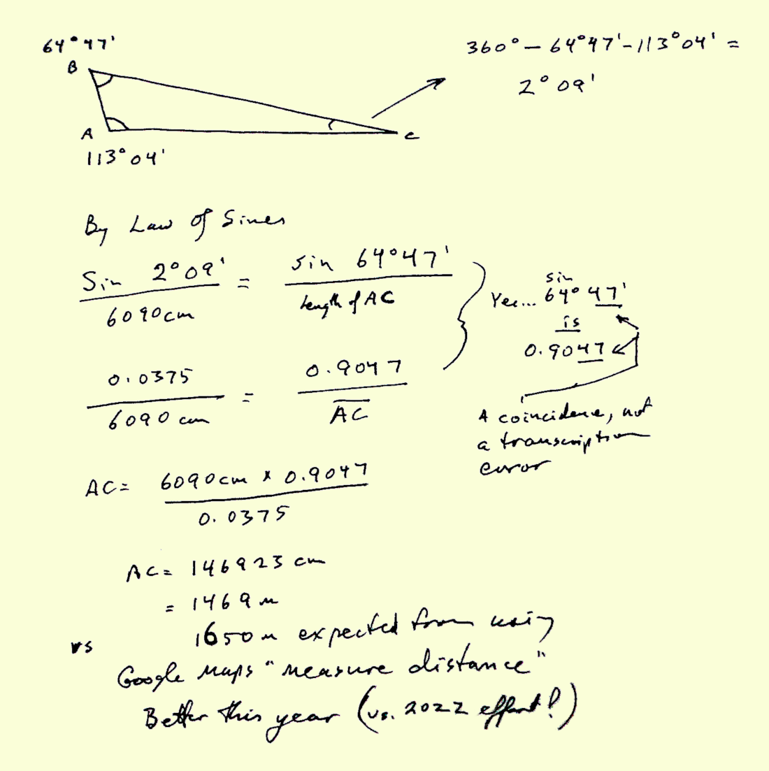
Using Google maps, as it says above, I determined by that perhaps more reliable... but more dependant- upon- others... route that the distance was probably about 1650 meters.
Also in the above: From just my own efforts... and those of the theolodite maker... I was able to get and answer of 1469. And that hasn't factored in what my other angle readings may tell me when I have time to look at them.
YOU, could do this! With just a plane table, if you don't have, or don't bother to make a theolodite. Do you have the patience, the ability to pay attention to details? Try it! See!
But you have what you need, if you combine what is here, and what is on other pages. Enjoy! And try making your own "maps"... even if like mine, one only depicts a baseline and a distant object.
If you found this of interest, please mention in forums, give it a Facebook "like", or whatever. If you want more of this stuff: help!? There's not much point in me writing these things, if no one hears about them. Does anyone feel they are of any use? If YOU do- please spread the word!
Search across several of my sites at once with a Google search button.
Or...
Or...
What's New at the Site Advanced searchUnlike the clever Google search engine, this one merely looks for the words you type, so....
* Spell them properly.
* Don't bother with "How do I get rich?" That will merely return pages with "how", "do", "I"....
Please also note that I have three other sites, and that this search will not include them. They have their own search buttons.
It's both! Flat-Earth-Academy.com is something I started years ago. For a variety of reasons, I can't offer you httpS:// access there. (As you are not asked to input any information, that's moot, but it "worries" search engines.) So I'm moving to my new, all singing, and will do the httpS:// dance site, "WYWTK.com", and Flat-Earth-Academy is gradually acquiring pages there. (Well, HERE, as what you are reading is one of my "wywtk/fea" pages.)
Why "WYWTK"? It comes from "What You Want To Know".
![]() Page has been tested for compliance with INDUSTRY (not MS-only) standards, using the free, publicly accessible validator at validator.w3.org. It passes in some important ways, but still needs work to fully meet HTML 5 expectations. (If your browser hides your history, you may have to put the page's URL into the validator by hand. Check what page the validator looked at before becoming alarmed by a "not found" or "wrong doctype".)
Page has been tested for compliance with INDUSTRY (not MS-only) standards, using the free, publicly accessible validator at validator.w3.org. It passes in some important ways, but still needs work to fully meet HTML 5 expectations. (If your browser hides your history, you may have to put the page's URL into the validator by hand. Check what page the validator looked at before becoming alarmed by a "not found" or "wrong doctype".)
AND tested for

. . . . . P a g e . . . E n d s . . . . .