
this page is a work in progress! But by 22 Oct 2022, (noon), it WILL have useful material on it!
These pages are meant to help you make a map. Yourself. No Google. No electronics.
[[DIGRESSION]]- If you are from the Chichester area, This Page Is (Particularly) For YOU!
(But it can be useful to others, as well!)]]
This page is meant to support people who think trying mapping by triangulation would be fun. (Mapping by triangulation discussed many times, many ways at my websites over the years! In October 2022 the place to start was http://wywtk.com/fea/sci/maps/ (Also accessible with https://bit.ly/MakeMyMap2... which is perhaps easier to remember when not in your bookmarks!
The page you are reading lets you "jump to the end".
If you follow the guidance on the main "MakeMyMap" pages you have quite a bit of work to do before you can try the actual drawing of the map.
The page you are reading lets you skip the fieldwork. It gives you "the numbers you need".
If you are from Chichester, and have measured angles from either the Trundle or Halnaker Mill, this page will save you trudging off to the other one, doing measurements from there, too. (Or you can even use this page to skip visiting EITHER hill!)
I would encourage you to go to the actual hills eventually. If you don't it isn't really YOU who made the map, is it?
qwhen the page is finished, you will find here...
Some angle measurements which are close to what you should get if one day you visit the hill in question and capture the angles for yourself. (So your map becomes more your map!)
It gives you the distance between the two hills. Something you are unlikely to measure for yourself anyway... but you know you could do it without Google, GPS, etc, don't you?
It xxxone-day-will tell you how to make the top of your map "north". (With just what's here, your map will probably have something near North at the top, anyway.)
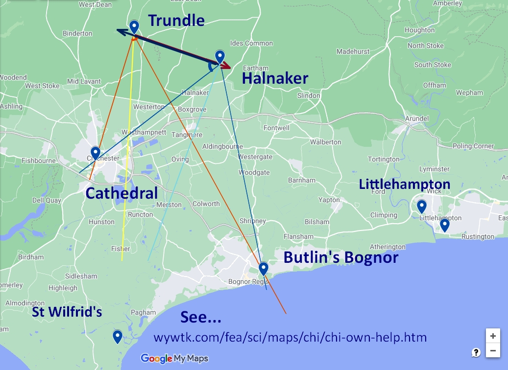
Here's a bigger copy of the image that was at the top of the page...
It shows a completed map, a map made by the method explained in this website.
If you study it and think a bit, it will help you get your map "right" first time. (True) north is very nearly "straight up" on this map.
It shows a bit more than that, but we'll come to what's extra in a bit.
Also "extra" is the green background. OUR map is still "a bit" limited. It only shows three points1 But if you can put three dots in the right places on a piece of paper, you know everything you need to know to put lots and lots of dots on the paper. (On the paper in the right places, even!)
The three dots are:
The two at the top marked "Trundle" and "Halnaker". These are the places angles were measured from.
And the one near the left side of the page, half way down, marked "Cathedral". If the angles were measured and drawn correctly, THAT is where the cathedral IS, relative to the Trundle and Halnaker Mill!
(You can check any map you draw by tracing the three points onto something transparent, and putting that in front of a screen showing a Google map. You'll need to zoom in and out, of course, until the screen scale is the same as your map's scale. // Notice: I don't call this "cheating", at all. You are merely checking your answer, finding out how close you came to what people with years of training and very, very expensive equipment are able to do.)
There are, of course, four angles involved in finding where the cathedral and Bognor Butlin's dots go. To minimize clutter, I've only put arcs on the diagram to show the two angles that make the lines that cross to indicate where the cathedral is.
Blue lines are about angles from Halnaker; orange/ yellow lines are about angles from the Trundle.
Here are the numbers... approximately!... that you would get if you went up the hills. These are enough to draw a pretty good map of where the Trundle, Halnaker, the Cathedral and Bognor Butlin's are...
From the Trundle to Halnaker: 4.46 km, aka 2.77 miles

From Halnaker, one arm pointing towards Trundle,
  other arm pointing at cathedral: 61 degrees
  other arm pointing at Butlin's: 121.5 degrees

From Trundle, one arm pointing towards Halnaker,
  other arm pointing at cathedral: 87.5 degrees
  other arm pointing at Butlin's: 42.5 degrees
If when you were on the Trundle and at Halnaker Mill you captured some other angles, you can put more dots on your map.
The huge white "tents" just east of Bognor are the Butlin's camp. They are easily seen from both of our high hills.
I drew in the lines that cross to tell you where Butlin's is.
Not so easy to find... you may need a telescope... but worth the effort is a small church on the west side of Pagham Harbour- "St Wilfrid's". There's a trig pillar there, which makes it a particularly nice place to get bearing from and to, if you can.
I also drew in the lines that cross to tell you where St Wilfrid's is, but in much less bold colors. (Pale yellow, pale blue. You should see them if you look!)
Not on the diagrams I've done for this page, but easy to see from both hills: Littlehampton. There is a tower block, and a gasometer. Getting the dot for Littlehampton in the right spot requires especially careful work... can you see why? (It's not "secret", but you should be proud of yourself if you can see... and explain... why.) (There is also a tower block in Bognor- another object you might want to place on your map.)
From Halnaker, one arm pointing towards Trundle,
  other arm pointing at St Wilfrid's: 90 degrees
  other arm pointing at Littlehampton: 15.2 degrees

From Trundle, one arm pointing towards Halnaker,
  other arm pointing at Wilfrid's: 83.0 degrees
  other arm pointing at Littlehampton: 12.0 degrees
If you go to...
https://www.google.com/maps/d/viewer?hl=en&hl=en&mid=1oQ....
You should find the same map... but you can "do things" with it.
(The full URL is visible if you hover your mouse over the link.)
In particular, to help you be sure you really understand what you are doing, try viewing it...
First with just the "Frm Trundle" layer turned off. (Click on the tick-mark).
Then with just the "Frm Halnaker" layer turned off.
Try explaining to someone else how maps are made with triangulation, using the interactive map. THEN you'll see if you really understand!
Okay... it only show where "A" "B" and "C" are... but you would just repeat that again and again, to make your map show the location of other points of interest.
If you found this of interest, please mention in forums, give it a Facebook "like", or whatever. If you want more of this stuff: help!? There's not much point in me writing these things, if no one hears about them. Does anyone feel they are of any use? If YOU do- please spread the word!
... OR...
Search across several of my sites at once with a Google search button.
Or...
Search (only) this site...
|
Unlike the clever Google search engine, FreeFind's merely looks for the words you type, so....
* Spell them properly.
* Don't bother with "How do I get rich?" That will merely return pages with "how", "do", "I"....
Disclosure: FreeFind tells me what people have searched for. It doesn't tell me your personal details. (If someone would "spy" on you, wouldn't they also feel free to lie in a "privacy statement"? Not to say I'm not lying... how can you tell?... but to say "What are privacy statements worth?".
Please also note that I have three other sites, and that this search will not include them. They have their own search buttons.
http://www.arunet.co.uk/tkboyd/index2.htm : My site at Arunet. Only http (no httpS) accessible, I fear. It asks you for no information. Why worry on pages that ask for no information?
It's both! Flat-Earth-Academy.com is something I started years ago. For a variety of reasons, I can't offer you httpS:// access there. (As you are not asked to input any information, that's moot, but it "worries" search engines.) So I'm moving to my new, all singing, and will do the httpS:// dance site, "WYWTK.com", and Flat-Earth-Academy is gradually acquiring pages there. (Well, HERE, as what you are reading is one of my "wywtk/fea" pages.)
Why "WYWTK"? It comes from "What You Want To Know".
![]() Page has been tested for compliance with INDUSTRY (not MS-only) standards, using the free, publicly accessible validator at validator.w3.org. It passes in some important ways, but still needs work to fully meet HTML 5 expectations. (If your browser hides your history, you may have to put the page's URL into the validator by hand. Check what page the validator looked at before becoming alarmed by a "not found" or "wrong doctype".)
Page has been tested for compliance with INDUSTRY (not MS-only) standards, using the free, publicly accessible validator at validator.w3.org. It passes in some important ways, but still needs work to fully meet HTML 5 expectations. (If your browser hides your history, you may have to put the page's URL into the validator by hand. Check what page the validator looked at before becoming alarmed by a "not found" or "wrong doctype".)
Tested for

And the links in the page have been tested (https://validator.w3.org/checklink).
. . . . . P a g e . . . E n d s . . . . .